It’s expected to be another scorching hot day in the Cowichan Valley before temperatures begin to decline into the low 30s later in the week.
Sunday’s temperature surpassed 39 degrees Celsius.
Today is expected to be just as hot and July and August are forecast to be hotter than normal.
On the weekend, Island Health was forced to close its vaccination clinic at the Cowichan Lake Sports Arena and vaccination appointments on Gabriola Island today are being rescheduled.
On Friday, the health authority had announced that due to the extreme heat the Ladysmith vaccination clinic would be temporarily relocated for the weekend, moving from the Aggie Hall to the Cedar Community Centre.
Cooling centres opened during the weekend at the Cowichan Community Centre, at the Siem Lelum Gym for members of Cowichan Tribes, and North Cowichan will open three cooling centres from 12 pm until 6 pm today at the Fuller Lake Arena, Crofton Community Centre, and the Chemainus Seniors Centre.
The record-breaking heatwave is caused by an exceptionally strong ridge of high pressure that’s been sitting above the province creating a heat dome, which traps warm air underneath it resulting in a heatwave that lingers for days.
Environment Canada meteorologists say the duration of this heatwave raises concerns about heat-related illnesses because night-time temperatures remained high.
Climate scientists are warning that these extreme temperature events will only become hotter in the coming years.
Gavin Schmidt of the Goddard Institute for Space Studies says “the last seven years have been the warmest seven years on record, typifying the ongoing and dramatic warming trend.”
The Institute says the average temperature for 2020 tied it with the previous record year of 2016.
According to Schmidt, “with these trends, and as human impact on the climate increases, we have to expect that records will continue to be broken.”
The World Meteorological Organization predicts there is a 90 per cent likelihood of at least one year between 2021-2025 becoming the warmest on record, which would dislodge 2020 and 2016 from the top ranking.
“These are more than just statistics,” according to WMO Secretary-General Prof. Petteri Taalas, “increasing temperatures mean more melting ice, higher sea levels, more heatwaves and other extreme weather, and greater impacts on food security, health, the environment and sustainable development.”
The organization says the 2020-2021 La Niña event has ended and neutral conditions are likely to dominate the tropical Pacific in the next few months, with air temperatures expected to be above average between June and August, especially in the northern hemisphere.
The WMO, however, says all naturally occurring climate events now take place in the context of human-induced climate change, which is increasing global temperatures, exacerbating extreme weather and impacting seasonal rainfall patterns.
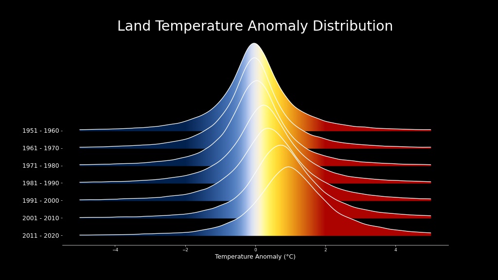
The Goddard Institute for Space Studies has posted a visualization showing how land temperature anomalies have shifted between 1951 and 2020 due to global warming.
According to GISS, as the planet has warmed temperature extremes have shifted into the higher range.
Created by NASA’s Scientific Visualization Studio


